Gravity Map Uncovers Sea-floor Surprises...
3 posters
Page 1 of 1
 Gravity Map Uncovers Sea-floor Surprises...

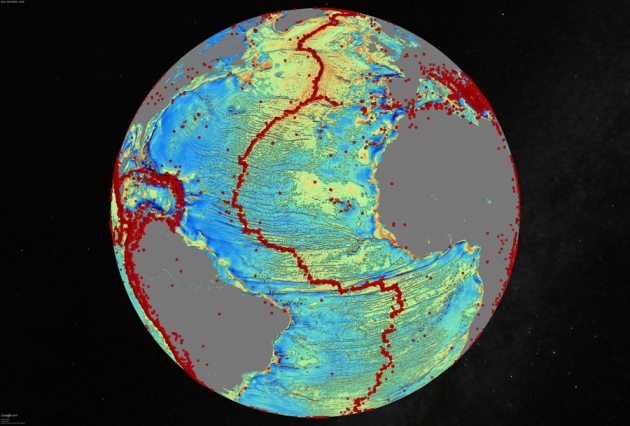
As though someone had pulled a plug in the oceans and drained them away, a sea-floor map has exposed thousands of never-before-seen underwater mountains and ridges. The map — generated by the highest-resolution gravity model ever made for the oceans — will guide deep-sea research for years to come.
An international team of researchers led by David Sandwell, an oceanographer at the Scripps Institution of Oceanography in La Jolla, California, publishes the map in the 3 October issue of Science1. The team created it using data mostly from two satellites: CryoSat-2, from the European Space Agency, and Jason-1, from NASA and the French space agency CNES.
Both satellites sought to chart the planet, but with different goals. The ongoing CryoSat-2 mission studies the polar ice caps, whereas Jason-1 studied changes in sea level before it was turned off last year. Both probes carried radar altimeters, instruments that measure the precise distance between the satellite and the surface of the land or ocean below.
From Here.
Tim.

Rockhopper- Posts : 4282
Join date : 2014-06-13
Age : 80
Location : Island Paradise
 Re: Gravity Map Uncovers Sea-floor Surprises...
Horse Latitudes......


Monk (in hiding)- Posts : 1993
Join date : 2014-06-15

Rogue- Posts : 37277
Join date : 2014-06-12
Location : Next to the Sandgroper
 Re: Gravity Map Uncovers Sea-floor Surprises...
Cool aren't they Roggie! We are starting to map the seafloor quite accurately now. Fascinating.
Tim.
Tim.

Rockhopper- Posts : 4282
Join date : 2014-06-13
Age : 80
Location : Island Paradise
Page 1 of 1
Permissions in this forum:
You cannot reply to topics in this forum
